
从中国北斗卫星导航系统官微获悉,近日,百度地图官方公告发布了北斗卫星导航系统应用的最新进展,北斗卫星日定位量首次突破1000亿次。
百度地图宣布正式切换为优先运用北斗系统进行定位,“百度地图智能定位开放服务”升级更名为“百度地图北斗定位开放平台”。
据了解,在北斗赋能下,百度地图升级实现了车道级导航、车位级导航等多项功能。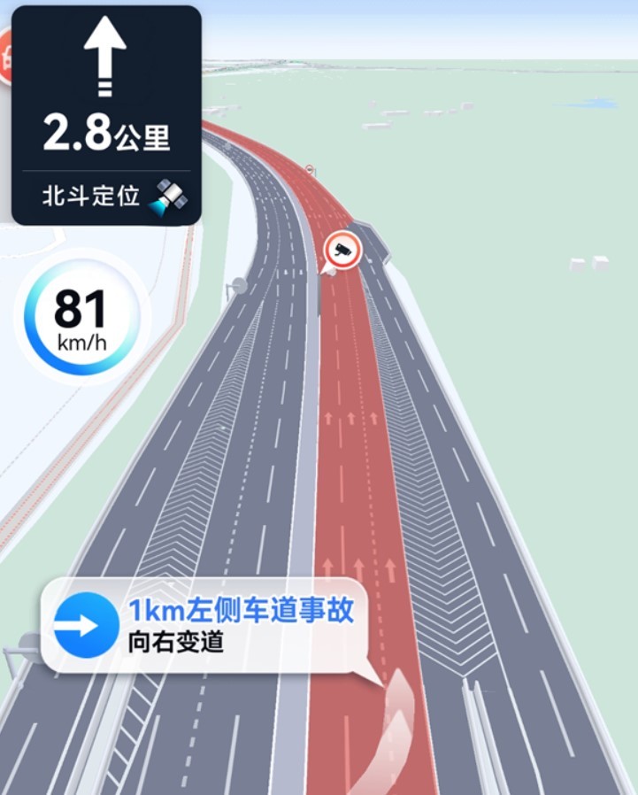
北斗系统助力实现“车道级导航”功能
北斗系统每天使用量破千亿:高德百度实现亚米级定位 手机导航更精准了
北斗系统助力实现“车位级导航”功能
车道级导航能够帮助用户在高、快速路行驶场景中,实时获取前方事故车道信息,动态引导用户提前避开危险车道;
车位级导航则针对停车场景中“停车难”的问题,为“亚洲最大停车场”北京荟聚购物中心和“亚洲最大综合铁路客运枢纽”北京丰台站提供服务。
此前,高德车道级导航也已经全面上线,它是北斗高精尖技术落地民用的创新服务。利用高清渲染技术最大程度还原真实道路场景,包括当前道路的车道数量、出入口等;应用北斗系统亚米级的高精度定位,将定位精度从5-10米的道路级,进化到小于1米的车道级别,实现高精细引导。
据了解,随着北斗三号全球卫星导航系统开通,我国空间和地面基础设施均已具备较为完善的服务能力,北斗应用和产业化逐步深入。北斗在地图导航中的新进展,是北斗应用服务大众的又一重要成果。
It was learned from the official website of China's Beidou satellite navigation system that Baidu Maps' official announcement recently released the latest progress in the application of the Beidou satellite navigation system. The daily positioning volume of Beidou satellites exceeded 100 billion times for the first time.
Baidu Maps announced that it has officially switched to the Beidou system for positioning, and the "Baidu Map Intelligent Positioning Open Service" has been upgraded and renamed "Baidu Map Beidou Positioning Open Platform".
It is understood that under the empowerment of Beidou, Baidu Maps has been upgraded to achieve lane-level navigation, parking space-level navigation and other functions.
Beidou system helps realize "lane-level navigation" function
The daily usage of Beidou system exceeds 100 billion: AutoNavi Baidu achieves sub-meter positioning and mobile phone navigation is more accurate
Beidou system helps realize the function of "parking level navigation"
Lane-level navigation can help users obtain real-time information on the accident lane ahead in high and expressway driving scenarios, and dynamically guide users to avoid dangerous lanes in advance;
Parking-level navigation is aimed at the problem of "difficult parking" in parking scenarios, and provides services for "Asia's largest parking lot" Beijing Huiju Shopping Center and "Asia's largest comprehensive railway passenger transport hub" Beijing Fengtai Station.
Prior to this, AutoNavi's lane-level navigation has also been fully launched. It is an innovative service for the civilian use of Beidou's advanced technology. Using high-definition rendering technology to restore the real road scene to the greatest extent, including the number of lanes, entrances and exits of the current road Lane level to achieve high-precision guidance.
It is understood that with the opening of the Beidou-3 global satellite navigation system, my country's space and ground infrastructure have already had relatively complete service capabilities, and the application and industrialization of Beidou has gradually deepened. The new progress of Beidou in map navigation is another important achievement of Beidou application serving the public.